
Babylonia and Across the River

Its hard to understand the Babylonian empire of Nebuchadnezzar and Nabonidus. Pagan texts in Aramaic were not selected to be copied and recopied by Christian scribes like Christian scribes copied some pagan Greek and Latin texts, and the heart of the empire fell to Cyrus without a fight. Burning cities can preserve texts painted on or pressed into clay, but archivists under Cyrus and Darius just continued to throw out old documents like they had under Nabopolassar, and so those documents were lost to us. Most surviving documents from the Neo-Babylonian empire are from temple or family archives which stuck to the old script and language, not the archives of the kings or governors which may not have been written on clay anyways. The famous Babylonian chronicles tell us about some events but not the structure of the kingdom or life in the provinces. By the time Greeks like Herodotus and Ctesias were writing, they were as vague on the difference between Assyrians and Babylonians as we are on the difference between upper and lower Egyptians. We know far more about Babylonia in the sixth century BCE than Greece in the sixth century BCE, but not everything (and not much about the rest of the empire). Some teaching in spring made me think of one of the oddest things about this empire.
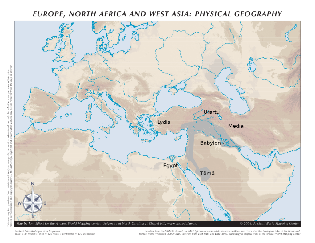
Contemporary texts tell us that the Babylonians campaigned in the west rather than the north, east, or south. They often crossed the Euphrates and drove the Egyptians of the Saite Dynasty out of Syria except for a bridgehead at Gaza, but they did not invade the lowlands of Elam or the highlands of Urartu and Elam. Urartu and Elam were no longer powerful kingdoms, although they may have had some kind of urban life, and the Medes in Iran seemed content to stay in the highlands as long as the Babylonians kept to the lowlands. Large stretches of the middle Euphrates run through a gorge in the desert, so there is no broad floodplain to feed a marching army, and unlike the Nile the Euphrates has no favourable wind to carry travellers upstream (before motorboats, travellers on the Euphrates normally let the current carry them downstream then sold their boats and walked or rode back). So anyone who wanted to lead an army north from Babylon followed the Tigris, crossed it upstream, and went west across the plains where they received enough rain to grow crops away from the rivers.
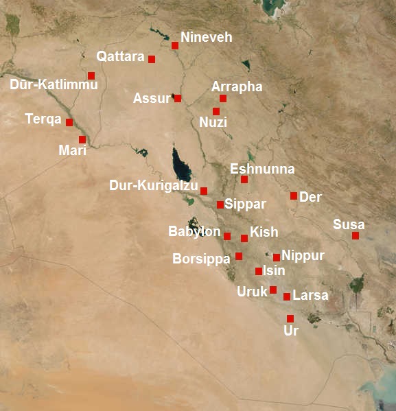
A hundred years earlier, these areas had been linked by the cities of the Assyrian heartland on the Khabur River and the plains between the rivers. But most of those cities had been destroyed and not rebuilt. The extensive network of canals and aqueducts which supported great cities had been ruined and the kings of Babylon were not willing to rebuild it. Even Harran, the city of the moon-god Sin in the plains between the Tigris and Euphrates, had been sacked when the last Assyrian kings took refuge there, and its temple was only rebuilt in Nabonidus’ day. As far as we can tell, this area was inhabited by small farmers and herders who grew crops from rainwater, but not city-folks and canal-builders. Cyrus the Great famously crossed the river Euphrates below Arbela and invaded a land whose name is lost, and the Babylonians could do nothing to stop him. From Damascus to Baghdad is about 750 km as the dove flies, and even today that is not a small distance. In 550 BCE there were only a handful of cities and towns in between.
Texts from the Neo-Babylonian period mention sites such as Guzana in the west and Arrapha in the east, and an archive of texts dated to the first Neo-Babylonian king were found at Dur-Katlimmu. Assur was still inhabited in some form, perhaps a small community clustered around the temple or a provincial governor.1 But most of the large cities of the Assyrian heartland such as Nineveh and Calah were heaps of ruins, leaving just sites on the eastern and western fringes of Assyria.
A.T. Olmstead made much of the Akkadian and Hebrew phrase “Babylon and beyond the river (ie. the Euphrates).” It seems that the old Babylonian empire was a single administrative unit under Cyrus, whereas Iran, Armenia, and Anatolia were governed separately. But this unit was strange, because it consisted of a densely populated heartland in Babylonia, a western periphery which was exploited for resources like iron and timber, and an area in between where the kings just collected modest taxes and passed through. In some ways it reminds me of Canada, where the dense rock of the Canadian Shield cuts off the rich farmland of the St Lawrence Valley and Southern Ontario from the prairies. The shield is good for mining and hunting and logging but little else, because the soils are too thin to grow crops and the water which sits on that dense rock breeds blackflies and mosquitos and makes road-building a nightmare. Canada has inescapable regional divisions because of that gap, and I am not surprised that the Babylonians found it necessary to have the crown prince stay in Babylonia while the king lived for years in the far west.
The Achaemenids dealt with this problem by moving towards the heartland of their new empire. They rebuilt Susa and made Ecbatana into a capital, and both were closer to the heart of their new empire than Pasargadae was. But the Babylonians never dreamed of rebuilding Assur. If we had the sources to see, I expect that would have been as controversial as Gaius Sempronius Gracchus’ proposal to rebuild Carthage and its key port in North Africa. The Neo-Babylonian kings presented themselves to the Babylonians as Marduk’s vicar on earth, and Marduk was the god of Babylon. They settled a few Babylonians on farms in Assyria but as long as the canal network was growing there was plenty of new land for Babylonians in Babylonia. And so Nebuchadnezzar and Nabonidus made do with an empire with an empty heart connecting western subjects and eastern rulers until Cyrus came and overthrew them. It must have been strange to march from the cities of Babylonia through land of farmsteads and villages to the far west with cities like Damascus and Tyre.
My domains are limited to the house and the orchard, and they don’t bring weighty tribute of shining silver or fragrant cedar or tasty dates. The word of the orientalist does not go as far as the word of the king or the writing on the wall. If you can share my writing, babble about it to a friend, or support this site I appreciate it!
Further Reading
Michael Jursa, “The Neo-Babylonian empire,” in M. Gehler and R. Rollinger, eds., Imperien und Reiche in der Weltgeschichte (Harrasowtiz Verlag: Wiesbaden, 2014) pp. 121-148 I wish I had this whole volume and the sequel on short-term empires (and time to create a map for this post)
Wikipedia on Post-Imperial Assyria is not bad!
(drafted April and May 2025)
- This is a complicated subject and I have run out of time to research even the written evidence let alone the archaeology. There are bits of information in Robert Rollinger, “The Median “Empire’, The End of Urartu and Cyrus the Great’s Campaign in 547 BC,” AWE 7 (2008) p. 57; Michael Jursa, “Observations on the problem of the Median ’empire’ on the basis of Babylonian sources,” In Lanfranchi et al., eds., Continuity of Empire (?) Assyria, Media, Persia (Padua, 2003) pp. 172-174 citing research by the late Amelie Kurt. I think I have another older article with a list of governors. ↩︎
Dear Sean,
thanks for the post and maps (especially agricultural), one of my biggest questions (without perfect answers) is how exactly looked like Neo-Babylonian empire in era 547-539 BC? We need map with borders of Babylonian provinces! I have reasonable doubts, that Babylonians were in war with Persians directly and indirectly for several years. For an example Persian conquest of Cilicia 545 BC meant the end of iron export to Babylonia (which could be interpreted as plan for war preparation). There is one Babylonian tablet (vis eds., Extraction & Control: Studies in Honor of Matthew W. Stolper, Oriental Institute of the University of Chicago 2014, p.111-5) describing Persian attacks on Syrian agricultural estates (c. 546 BC I think).
Another problem of Babylonia is northern border, province Gutium could be lost in 550’s BC era (553 or 550), or 543 BC (even 540/39 BC is plausible). Old Assyrian heartland, and Charran could be taken by Persians in 550’s BC era and certainly in 546 BC (Parpola was writting about Assyrian revolts in 546 BC and 520 BC against Persia) or slightly later. There are primary sources proving Persian attacks on northern and southern part of Babylonia. Maybe only Syria, Phoenicia, Judea, Arabia was still in Nabonid hands, but nothing more before Persian onslaught.
Thanks to cold war with Medes since 590’s era BC, the Median wall was built (I presume finished), but nobody is telling me, where it was breached (or bribe accepted? treason?). Sadly all these questions are without attention (except academics like https://uw.academia.edu/MalgorzataSandowicz/Papers). I still didn’t find co-worker who wants to write study about this theme with me (work title Fall of Babylon 539 BC, not a Persian blitzkrieg).